Military and Traffic Maps
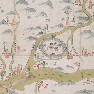
龍游縣境塘汛輿圖
Military Map of Longyou County| Hanyu Pinyin | Longyou Xian jing tang xun yu tu |
|---|---|
| Date | Between Qing Jiaqing and Daoguang period, 1800-1840. |
| Measurement | |
| Techniques | Ink and color manuscript |
| Material | paper |
| Quantity | |
| Categories | |
| Country of Repository | |
| Identifier | British Library |
| Link to Original Database | http://explore.bl.uk/primo_library/... |
| Notes | Add. MS. 16361 (H) |
| Share |
No title appears on this map; the title applied here is based on content. Scale and legend are not given; orientation is marked along the borders on all four sides with north at the bottom. Longyou County was under the jurisdiction of Chuzhou Prefecture. The map depicts Longyou County pictorially, while mountains, military stations, and temples are explained in annotations. The county seal in Manchu and Chinese is stamped on the top. This is an official military map. There isn’t enough information given to estimate when the map was made; however, judging from the military posts established Jiangnan, the map may have been drawn during the Qing Jiaqing and Daoguang period, 1800-1840.
This map can be contrasted with the following maps in the National Palace Museum’s collection: Zhejiang Quzhou Fu dao li tu (map no. 021494); Zhejiang quan sheng dao li zong tu (map no. 021505-021506); Zhejiang quan sheng tu (map no. 021589); and the Library of Congress collection: Zheijiang quan tu (gm 71005029); Zhejiang yan hai yao kou quan tu (gm 2002626763); Ning Jun di yu tu (gm 71002469); Qiantangjian yan an tu (gm 71005077); Jiang hai quan tu (gm 71005059).
This map can be contrasted with the following maps in the National Palace Museum’s collection: Zhejiang Quzhou Fu dao li tu (map no. 021494); Zhejiang quan sheng dao li zong tu (map no. 021505-021506); Zhejiang quan sheng tu (map no. 021589); and the Library of Congress collection: Zheijiang quan tu (gm 71005029); Zhejiang yan hai yao kou quan tu (gm 2002626763); Ning Jun di yu tu (gm 71002469); Qiantangjian yan an tu (gm 71005077); Jiang hai quan tu (gm 71005059).