Military and Traffic Maps
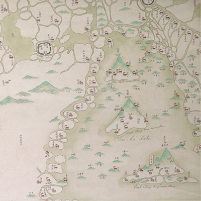
江南水陸營汛全圖
Military Map of Jiangnan Corps in Jiangsu Province| Hanyu Pinyin | Jiangnan shui lu ying xun quan tu |
|---|---|
| Date | Before the 23rd year of Qing Daoguang's reign, -1843. |
| Measurement | |
| Techniques | Ink and color manuscript |
| Material | silk |
| Quantity | |
| Categories | |
| Country of Repository | |
| Identifier | British Library |
| Notes | Or. 11528 |
| Share |
No title appears on this map; the title applied here is based on content. Legend is not given; north is at the top. The Chinese scale was given as “each grid represents 20 li” (approximately 7 miles). The map depicts battalions pictorially and identified each by name. Jiangnan Corps had jurisdiction over five divisions. The governed area including Prefectures of Zhenjiang, Changzhou, Suzhou, Songjiang and Taicang municipality. Each brigade is depicted by a symbol of town walls; checkpoints and artillery forts are represented pictorially accompanied by annotations. This is a detailed official military map.
Based on the information given, the map may have been drawn before the 23rd year of Qing Daoguang’s reign, 1843. There are several English annotations and battle symbols. The map also shows circles and radiation shapes spread out from the center of Shanghai, indicating that the map may have been used by the westerners during the battles between the coalition of Qing soldiers and foreign armies centered in Shanghai as a base against Taiping Rebellion around the 10th year of Xianfeng’s reign, 1860.
This map can be contrasted with the following maps in the National Palace Museum’s collection: Jiangsu hai fang tu (map no. 021513); Baoshan Xian hai tang tu (Grand Council file no. 046243-a); Ge sheng yan hai kou ai quan tu (map no. 020867); Yan hai chang tu (map no.020868); Jiangnan ge dao fu tu biao cun (map no. 020923-020941); and the Library of Congress collection: Jiang hai quan tu (gm 71005059); Qi sheng yan hai quan tu (gm 71005064); Hai jiang yang jie xing shi tu (gm 71005021); Shandong, Zhili, Shengjing hai jiang tu (gm 71005062); Nan bei yang he tu (gm 71005215); Nan yang fen tu (gm 71005139); Bei yang fen tu (gm 71005226).