City Maps
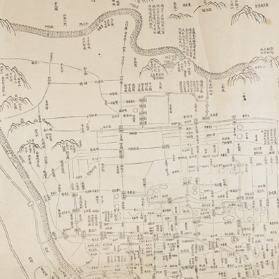
江寧省城圖
Urban Plan of Jiangning| Hanyu Pinyin | Jiangning Sheng cheng tu |
|---|---|
| Creator | Yuan Qingshou |
| Date | 清咸豐6年(1856) |
| Measurement | |
| Techniques | Pen-and-ink on paper |
| Material | paper |
| Quantity | |
| Categories | |
| Country of Repository | |
| Identifier | British Library |
| Notes | Or. 5502 |
| Share |
Title is written on the top right; scale, legend, and orientation are not given on the map. North is at the top judging from the content. The map includes explanatory text of the background and history of Nanjing, including town walls, government offices, barracks, neighborhood alleys, rivers, bridges, and temples, scenic attractions, historical sites, and battlefields. The map is drawn in the traditional flat mapping style, but the town wall is shown pictorially.
Yuan Qingshou, who was the magistrate of Liuyang County, Hunan Province at the time, made this map based on the map drawn between 1829 and 1853. Yuan Qingshou was also known as Xitai, and his style name was Hanlun. He was a successful candidate in the imperial examinations at the county level and the author of many books.
This map can be contrasted with the following maps in the National Palace Museum’s collection: Jinling ge ying lu jie jie wei tu (map no. 021291.001); Jinling ge ying lu jie jie wei tu (map no. 021291.002); Ke fu Jinling tu (map no. 021293.001); and the Library of Congress collection: Jiangsu quan tu (gm 71005111); Qing jun wei gong Jinling Cheng tu (gm 71005033).