City Maps
嚴州府暨建德縣輿圖
Map of Yanzhou Prefecture and Jiande County| Hanyu Pinyin | Yanzhou Fu ji Jiande Xian yu tu |
|---|---|
| Date | Qing Daoguang peiod, 1825-1843. |
| Measurement | |
| Techniques | Ink and color manuscript |
| Material | paper |
| Quantity | |
| Categories | |
| Country of Repository | |
| Identifier | British Library |
| Link to Original Database | http://explore.bl.uk/primo_library/... |
| Notes | Add. MS. 16358 (F) |
| Share |
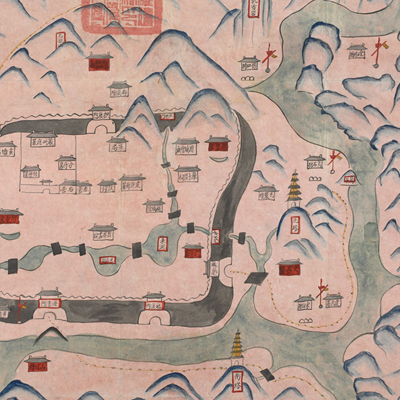
No title appears on this map; the title applied here is based on content. No scale or legend is given; orientation is marked along the borders on all four sides with north at the top. The map uses a traditional Chinese pictorial style to depict town walls, government offices, colleges, check points, training fields, and temples. All names are identified. An official seal in both the Chinese and Manchu languages was stamped on the top of the map. Yanzhou Prefecture is under the jurisdiction of Zhejiang, consisted of six counties (Jiande, Chun’an, Tonglu, Sui’an, Shouchang, Fenshui). Jiande is the attached county of the Yanzhou Prefecture. The map depicts the prefectural capital and geographic features of Jiande County, especially the military sites.
Jiande County and the Yanzhou Prefecture shared the same capital town whose walls had endured wars and battles; the prefect Sun Dehan and the magistrate Zhou Xingyi applied for funding to repair the walls in 1821. The map shows the east and southern gates re-opened after repair. The map may have been drawn during Daoguang period, 1825-1843.
This map can be contrasted with the following maps in the National Palace Museum’s collection: Zhejiang Yanzhou Fu dao li tu (map no. 021495); Zhejiang quan sheng dao li zong tu (map no. 021505-6); Zhejiang quan sheng tu (map no. 021589); and the Library of Congress collection: Zheijiang quan tu (gm 71005029); Zheijiang quan tu (gm 96685902).