City Maps
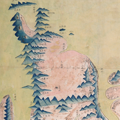
象山縣境輿圖
Map of Xiangshan County| Date | Before the second year of Qing Daoguang’s reign, -1822. |
|---|---|
| Measurement | |
| Techniques | Ink and color manuscript |
| Material | paper |
| Quantity | |
| Categories | |
| Country of Repository | |
| Identifier | British Library |
| Link to Original Database | http://explore.bl.uk/primo_library/... |
| Notes | Add. MS. 16359 (K) |
| Share |
No title appears on this map; the title applied here is based on content. No scale or legend is given; orientation is marked along the borders on all four sides with north at the bottom. The map depicts geographic features pictorially such as cities, flood seasons, temples, mountains, and islands. Place names are indicated and supplemented with explanatory text. The map covers Xiangshan Peninsula and its surrounding islands, including Nantian. Since Qianlong’s reign, many initiatives for reclaiming Nantian were proposed. In the second year of Daoguang, 1822, a proposal was made to send an administrative official to govern the island. Since this establishment was not shown on the map, this map may have been drawn before 1822.
This map can be studied with the following maps in the National Palace Museum’s collection: Zhejiang Ningbo Fu di yu tu shuo (map no. 020965); Zhejiang Ningbo Fu dao li tu (map no. 021491); Zhejiang Ningbo Fu shu di li yu tu (map no. 021510); Zhejiang Fujian yan hai hai fang tu (map no. 020869); Shimen Zhen bei di er zhan zhi Haining Xian Tangqi Zhen Daying dao li tu shuo (map no. 020819); Zhejiang Sheng Haitang tu (map no. 020880); Zhejiang Shaoxing Fu shu di li yu tu (map no. 020966); Zhejiang Shaoxing Fu di yu tu shuo (map no. 021309); Zhejiang Shaoxing Fu dao li tu (map no. 021492); Zhejiang Shaoxing Fu shu di tu (map no. 021520); and the Library of Congress collection: Zheijiang quan tu (gm 71005029); Jiang hai quan tu (gm 71005059); Zhejiang yan hai yao kou quan tu (gm 2002626763); Ning Jun di yu tu (gm 71002469).
This map can be studied with the following maps in the National Palace Museum’s collection: Zhejiang Ningbo Fu di yu tu shuo (map no. 020965); Zhejiang Ningbo Fu dao li tu (map no. 021491); Zhejiang Ningbo Fu shu di li yu tu (map no. 021510); Zhejiang Fujian yan hai hai fang tu (map no. 020869); Shimen Zhen bei di er zhan zhi Haining Xian Tangqi Zhen Daying dao li tu shuo (map no. 020819); Zhejiang Sheng Haitang tu (map no. 020880); Zhejiang Shaoxing Fu shu di li yu tu (map no. 020966); Zhejiang Shaoxing Fu di yu tu shuo (map no. 021309); Zhejiang Shaoxing Fu dao li tu (map no. 021492); Zhejiang Shaoxing Fu shu di tu (map no. 021520); and the Library of Congress collection: Zheijiang quan tu (gm 71005029); Jiang hai quan tu (gm 71005059); Zhejiang yan hai yao kou quan tu (gm 2002626763); Ning Jun di yu tu (gm 71002469).