City Maps
鄞縣地輿圖
Map of Yin County| Hanyu Pinyin | Yin Xian di yu tu |
|---|---|
| Date | Before the 13th year of Qing Jiaqing's reign, -1808. |
| Measurement | |
| Techniques | Ink and color manuscript |
| Material | paper |
| Quantity | |
| Categories | |
| Country of Repository | |
| Identifier | British Library |
| Link to Original Database | http://explore.bl.uk/primo_library/... |
| Notes | Add. MS. 16359 (G) |
| Share |
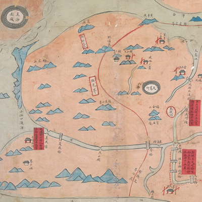
No title appears on this map; the title applied here is based on content. Scale and legend are not given; orientation is marked along the borders on all four sides with north at the bottom. Yin County was the attached county of Zhejiang Ningbo Prefecture. Its size was 65 li from east to west, and 70 li from north to south. Yin County was bordered by Zhenhai County to the east, Fenghua County to the west, and Xiangshan County to the south. It is roughly the area circled by the red coil on the map. The map depicts pictorially the capital town shared by Ningbo Prefecture and Yin County. The capital towns of Zhenhai County and Dinghai County, Dasongsuo, bridges, piers, coastal islands, and hills are also illustrated. Three red labels are affixed to the map to note geographic information. Independent military units are depicted with red dotted lines. Zhenhai County is located on the map. Judging from the distributions of waterways, the map may have been drawn before the 13th year of Qing Jiaqing’s reign, 1808.
This map can be contrasted with the following maps in the National Palace Museum’s collection: Zhejiang Ningbo Fu di yu tu shuo (map no. 020965); Zhejiang Ningbo Fu dao li tu (map no. 021491); Zhejiang Ningbo Fu shu di li yu tu (map no. 021510); Zhejiang Fujian yan hai hai fang tu (map no. 020869); and the Library of Congress collection: Zheijiang quan tu (gm 71005029); Jiang hai quan tu (gm 71005059); Zhejiang yan hai yao kou quan tu (gm 2002626763); Ning Jun di yu tu (gm 71002469).
This map can be contrasted with the following maps in the National Palace Museum’s collection: Zhejiang Ningbo Fu di yu tu shuo (map no. 020965); Zhejiang Ningbo Fu dao li tu (map no. 021491); Zhejiang Ningbo Fu shu di li yu tu (map no. 021510); Zhejiang Fujian yan hai hai fang tu (map no. 020869); and the Library of Congress collection: Zheijiang quan tu (gm 71005029); Jiang hai quan tu (gm 71005059); Zhejiang yan hai yao kou quan tu (gm 2002626763); Ning Jun di yu tu (gm 71002469).