City Maps
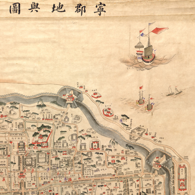
寧郡地輿圖
Map of Ningbo| Hanyu Pinyin | Ning Jun di yu tu |
|---|---|
| Creator | Anonymous |
| Date | Mid-Qing period, 1846- |
| Measurement | |
| Techniques | Ink and color manuscript |
| Material | paper |
| Quantity | |
| Categories | |
| Country of Repository | |
| Identifier | Library of Congress |
| Link to Original Database | http://lccn.loc.gov/gm71002469 |
| Acquisition Date | 1938.11.30 |
| Share |
This is a bird's eye view of Ningbo. North is at the top. On the right side of the map, pontoon bridges, city walls, buildings, boats, and ships are depicted. The map combines traditional pictorial features with three-dimensional images; features such as alleys, rivers, lakes, bridges, government offices, temples, and towers are exquisitely drawn in different colors.
The map is not drawn to scale and contains sketchy detail. It is a typical Chinese traditional city map. The map was made after the Treaty of Nanjing was signed in 1842 when Ningbo was opened for foreign trade.
The map is not drawn to scale and contains sketchy detail. It is a typical Chinese traditional city map. The map was made after the Treaty of Nanjing was signed in 1842 when Ningbo was opened for foreign trade.