City Maps
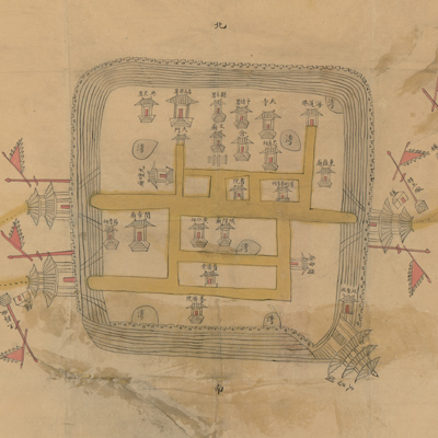
萊州府昌邑縣城垣圖
Map of Changyi County, Laizhou Prefecture| Hanyu Pinyin | Laizhou Fu Changyi Xian cheng yuan tu |
|---|---|
| Creator | Anonymous |
| Date | Late Qing period, 1888- |
| Measurement | |
| Techniques | Ink and color manuscript |
| Material | paper |
| Quantity | |
| Categories | |
| Country of Repository | |
| Identifier | Library of Congress |
| Link to Original Database | http://lccn.loc.gov/gm71005051 |
| Acquisition Source | Hummel, Arthur William, 1884-1975 |
| Acquisition Method | |
| Acquisition Date | 1930 |
| Share |
The map is an official document mounted on yellow paper with the title written on a red label pasted on the verso. North is at the top and buildings are sketchily drawn. The map depicts the city layout and the postal roads outside the city. City walls are portrayed by multiple lines. There are two city gates on the west and one on the east. The map also shows Wenchang Pavilion at the bottom right, major roads, ponds, government offices, temples, ancestral halls, places of worship, and military bases (tun). The map is not drawn to scale or to actual proportion. This is a typical city map that only depicts the city outline and relative location of buildings.
The map can be studied with the following map in the National Palace Museum's collection: title: Shandong Laizhou Fu yu tu (map no. 021451).
The map can be studied with the following map in the National Palace Museum's collection: title: Shandong Laizhou Fu yu tu (map no. 021451).