City Maps
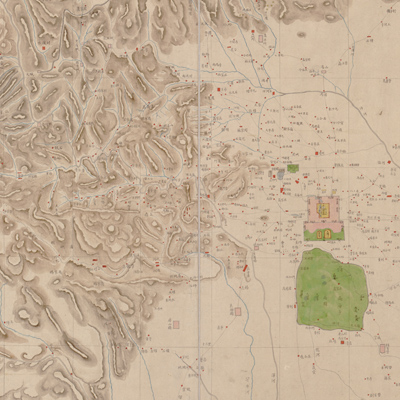
北京城郊圖
Map of Beijing and its environs| Hanyu Pinyin | Beijing cheng jiao tu |
|---|---|
| Creator | Anonymous |
| Date | Late Qing Period, 1886 |
| Measurement | |
| Techniques | Ink and color manuscript |
| Quantity | |
| Categories | |
| Country of Repository | |
| Identifier | Library of Congress |
| Link to Original Database | http://lccn.loc.gov/gm71002466 |
| Acquisition Source | Rockhill, William Woodville, 1854-1914 |
| Acquisition Method | |
| Acquisition Date | 1899 |
| Share |
Notes along the bottom right contain the donor's signature and the following contents: “Map of Peking, the environs. Drawn by Chinese from European surveys. Circa 1886. Peking. Presented to the Library of Congress by William Rockhill.” The map was drawn by a Chinese cartographer based on a European survey. The map depicts Beijing and suburban areas. The map depicts the mountains, rivers, cities, villages, and roads of Beijing.
The map can be studied with the following maps in the National Palace Museum's collection: title: Huang cheng gong dian ya shu tu (map no. 021601); title: Beijing gong dian tu (map no. 021470).
The map can be studied with the following maps in the National Palace Museum's collection: title: Huang cheng gong dian ya shu tu (map no. 021601); title: Beijing gong dian tu (map no. 021470).