City Maps
京師九城全圖
Complete map of the nine inner cities of Beijing| Hanyu Pinyin | Jing shi jiu cheng quan tu |
|---|---|
| Creator | Anonymous |
| Date | Late Qing period, 1900- |
| Measurement | |
| Techniques | Ink and color manuscript |
| Material | silk |
| Quantity | |
| Categories | |
| Country of Repository | |
| Identifier | Library of Congress |
| Link to Original Database | http://lccn.loc.gov/gm71002465 |
| Acquisition Source | Hummel, Arthur William, 1884-1975 |
| Acquisition Method | |
| Acquisition Date | 1934 |
| Share |
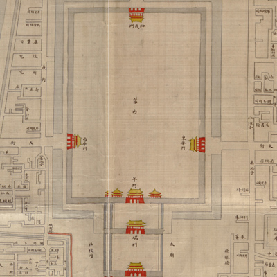
The Beijing city wall was built between 1436 and 1553. The inner city wall was 15 metres high, and it had nine gates for the inner city of the capital, also known as the nine inner cities. Beijing was the capital city of five dynasties in Chinese history. Beijing consists of the Forbidden City, the Imperial City, the inner city, and the outer city. It had the most extensive defensive system in Imperial China. Fortifications included gate towers, gates, archways, watchtowers, barbicans, barbican towers, barbican gates, barbican archways, sluice gates, sluice gate towers, enemy sighting towers, corner guard towers, and a moat system.
The outline of the Forbidden City is drawn in red lines; the rest of Beijing uses dark ink. The map was made during the late Qing Dynasty. The map depicts the major landmarks: city gates, archways, water systems, and street layouts of Beijing, especially the inner city, also known as the North City. Streets and alleys are identified; mansions are indicated but not named.
The map can be studied with the following maps in theNational Palace Museum's collection: title: Huang chenggong dian ya shu tu (map no. 021601); title: Beijing gongdian tu (map no. 021470).Studying these maps together make one see the changes from the early and late Qing period.