Military and Traffic Maps
南洋分圖
Coastal map of the South China| Hanyu Pinyin | Nan Yang fen tu |
|---|---|
| Creator | Hubei Guan Shu Ju |
| Date | After 9th Year of Qing Tongzhi Reign, 1870- |
| Measurement | |
| Techniques | Woudcut |
| Material | paper |
| Quantity | |
| Categories | |
| Country of Repository | |
| Identifier | Library of Congress |
| Link to Original Database | http://lccn.loc.gov/gm71005139 |
| Acquisition Date |
| Share |
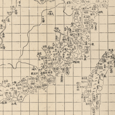
This map and three others, “Nan Bei Yang he tu”, “Bei Yang fen tu”, and “Dian, Yue, Yuenan lian jie yu tu”, belong to the same set. Text at the bottom left states that the Chinese cartographic grid is applied and a side of each grid represents 100 li (approximately 33 miles). Different symbols represent different administrative divisions, such as provincial capitals, counties, cities, mills, and checkpoints. The map depicts southern China's coastal terrain. The map covers territory from the Yellow River mouth in the northern part of Jiangsu Province to the border of Guangdong and Guangxi provinces in the south, including Taiwan and the Hainan islands. These areas are governed by the Nan Yang Minister who was in charge of Jiangsu, Zhejiang, Fujian, Guangdong provinces, coastal territories, islands, and the middle and downstream watersheds of the Yangtze River. The coastal areas were mapped in much greater detail than the inland areas.
This map can be studied with the following maps in the National Palace Museum's collection: title: Ge sheng yan hai kou ai quan tu (map no. 020867); title: Yan hai an chang tu (map no. 020868); title: Zhejiang Fujian yan hai hai fang tu (map no. 020869).
This map can be studied with the following maps in the National Palace Museum's collection: title: Ge sheng yan hai kou ai quan tu (map no. 020867); title: Yan hai an chang tu (map no. 020868); title: Zhejiang Fujian yan hai hai fang tu (map no. 020869).