Military and Traffic Maps
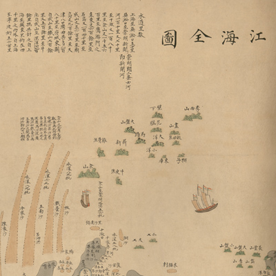
江海全圖
Complete map of rivers and coastline| Hanyu Pinyin | Jiang hai quan tu |
|---|---|
| Creator | Anonymous |
| Date | Mid-Qing period, 1812-1843 |
| Measurement | |
| Techniques | Ink and color manuscript |
| Material | paper |
| Quantity | |
| Categories | |
| Country of Repository | |
| Identifier | Library of Congress |
| Link to Original Database | http://lccn.loc.gov/gm71005059 |
| Acquisition Source | Hummel, Arthur William, 1884-1975 |
| Acquisition Method | |
| Acquisition Date | 1934 |
| Share |
The map is oriented with north to the left. The bottom depicts the Chinese coast; the top depicts the Bo Hai Sea, Yellow Sea, and East Sea. Drawn in traditional landscape style, the map depicts the coastline of Zhejiang, Jiangsu, Shandong, Zhili, and Shengjing. The map shows administrative divisions in coastal provinces, prefectures, states, counties, cities, and townships; the map also
depicts mountains, rivers, ports, bays, estuaries, islands, sandbars, temples, the Shanhaiguan Pass, and city walls; administrative divisions are represented with different round and square symbols.
The mapmaker made a deliberate effort to record coastal shoals, water depth, and nautical knots. The notes on the top right record the mileage along waterways. Notes also prompt sailors to navigate carefully, avoid reefs, and note the accumulation of sand in the mouth of the river. The map focuses on Shandong and Liaodong Peninsula coastal or estuary details, such as river mouths, river ports, and river spits. To measure water depth, it is absolutely necessary to measure from the left and then the right side of the ship; wax the lead ball to provide the sediment sample.
The Yellow river entered the sea from north Jiangsu on this map. The map has several corrected typographical errors. For example, for Yangzhou and Baoding: the word “ning” was used multiple times, while Beijing was written as “Jingdu” or “Nanjing”. This doesn't comply with Chinese idiom; the map may have been made by a Japanese or Korean mapmaker.
This map can be studied with the following maps in the National Palace Museum's collection: title: Bo Hai yan an dao li tu (map no. 021471); title: Hai tu (map no. 020865); title: Yan hai an chang tu (map no. 020868).