Military and Traffic Maps
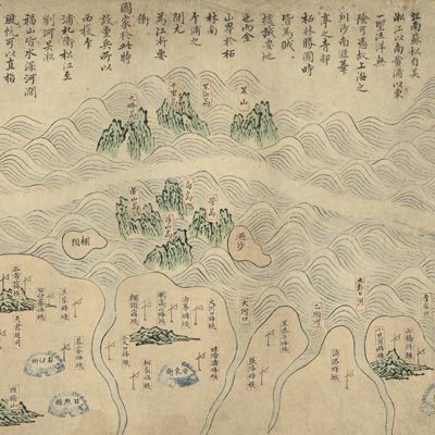
山東、直隸、盛京海疆圖
Coastal map of Shandong, Zhili, and Shengjing| Hanyu Pinyin | Shandong, Zhili, Shengjing hai jiang tu |
|---|---|
| Creator | Anonymous |
| Date | Early Qing period, 1634-1652 |
| Measurement | |
| Techniques | Ink and color manuscript |
| Material | paper |
| Quantity | |
| Categories | |
| Country of Repository | |
| Identifier | Library of Congress |
| Link to Original Database | http://lccn.loc.gov/gm71005062 |
| Acquisition Source | Hummel, Arthur William, 1884-1975 |
| Acquisition Method | |
| Acquisition Date | 1962 |
| Share |
The map scroll depicts coastal areas and key coastal defense locations. The map covers territory from Ganyu, Haizhou Bay in the Yellow Sea to Jinzhouwei on the southern end of Liaodong Peninsula. The map is a typical coastal map facing the sea with land on the bottom. The names for coastal provinces, counties, guards and patrol divisions, tribes, river ports, islands, and mountains are listed; corresponding positions are given. The mountains, rivers, city walls, towns, and lighthouses are represented with special symbols.
Shenyang changed its name to Shengjing in 1634. Based on place names changes that appear on the map, it is thought that the map was made between 1634 and 1652.
This map can be studied with the following maps in the National Palace Museum's collection: title: Hai tu (map no. 020865); title: Ge sheng yan hai kou ai quan tu (map no. 020867); title: Yan hai an chang tu (map no. 020868); title: Zhejiang Fujian yan hai hai fang tu (map no. 020869).