Military and Traffic Maps
新嶍營輿圖
Map of Xinxi Army Barrack| Hanyu Pinyin | Xinxi Ying yu tu |
|---|---|
| Creator | Anonymous |
| Date | Mid-Qing period, 1770-1840 |
| Measurement | |
| Techniques | Ink and color manuscript |
| Material | paper |
| Quantity | |
| Categories | |
| Country of Repository | |
| Identifier | Library of Congress |
| Link to Original Database | http://lccn.loc.gov/gm71005106 |
| Acquisition Source | Hummel, Arthur William, 1884-1975 |
| Acquisition Method | |
| Acquisition Date | 1930 |
| Share |
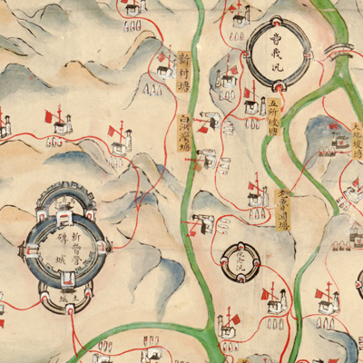
No title appeares on the map; the title applied here is based on content. North is at the top. Annotations along the four sides of the map note the adjoining border counties and boundaries. The Xinxiying is the designated barrack name for the Green Standard Army of Xinping County in the Qing Dynasty; it is part of Xi'e County. According to the National Palace Museum's “Illustrated map of Lin'an Fu in Yunnan” (mapno. 021302):" Xi'e County is 160 li northwest of Lin'an County where the Xiniman tribe lived during the ancient Tang Dynasty.” Xi'e County was established in 1289, Yuan Dynasty, and continued until the Ming Dynasty under the jurisdiction of Lin'an County. The Qing Dynasty followed the
Ming's government structure. The caption on the bottom of the map cited“Yuanjiang Zhilizhou”; Yuanjiang was changed from prefecture to state in the 35th Year of Qing Qianlong Reign (1770). Today, cartographers believe the map was drawn after the mid-Qianlong period; this conclusion is based on facts that appear on the map.
Xinxiying barrack is positioned in the center of the map; other barracks spread out in all directions. This is a typical Qing Dynasty military map with features shown pictorially. The map depicts mountains, towns, camps, towers, rivers, roads, and bridges. In addition, yellow labels with annotations are pasted to the map.
This map can be studied with the following maps in the National Palace Museum's collection: title: Yunnan jun ying tu (map no. 021502); title: Yunnan yu di tu shuo (map no. 021302-021303); title: Yunnan zong tu (map no. 021460-021461); title: Yunnan Sheng di tu (map no. 021478); title: Yunnan quan sheng dao li tu shuo (map no. 021299).