Political and Boundary Maps
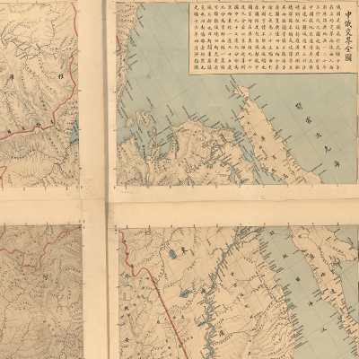
中俄交界全圖
China – Russia border map| Hanyu Pinyin | Zhong E jiao jie quan tu |
|---|---|
| Creator | Hong Jun |
| Date | The 16th Year of Qing Guangxu Reign, 1890 |
| Measurement | |
| Techniques | Lithograph, hand-colored |
| Material | Lithograph |
| Quantity | |
| Categories | |
| Country of Repository | |
| Identifier | Library of Congress |
| Link to Original Database | http://lccn.loc.gov/gm71005082 |
| Share |
The title and text are at top right; legend and scale are at bottom right. Each sheet is written in Chinese characters representing metal, wood, water, fire, and earth on the upper left corner for sheet sequence. The map adopts modern mapping techniques, including a conic equidistant projection and geographic coordinates; the meridian passes through St. Petersburg, the Russian capital. The map depicts the Sino-Russian border from northeast Heilongjiang to northwest Lake Balkhash. The detailed map applied colors and standard symbols. Trilateral borders and topography are portrayed in different colors: the Chinese border is indicated in yellow; Russian in red; and Korean in orange. Relief is shown by hachures; cities, the Great Wall, and roads are depicted with standard symbols. The map is based on the translated and revised version of the Russian map originally published in 1884. The map can be studied with the following map in the National Palace Museum's collection: title: Guangxu kan ding xi bei bian jie e wen yi han tu by Xu Jingcheng (map no. 021421- 021422).