Political and Boundary Maps
滇粵、越南聯界輿圖
China – Vietnam border map| Hanyu Pinyin | Dian Yue Yuenan lian jie yu tu |
|---|---|
| Creator | Hubei guan shu ju |
| Date | Mid-Qing period, 1870- |
| Measurement | |
| Techniques | Woodcut |
| Material | paper |
| Quantity | |
| Categories | |
| Country of Repository | |
| Identifier | Library of Congress |
| Link to Original Database | http://lccn.loc.gov/gm71005069 |
| Acquisition Date | 1959.12.03 |
| Share |
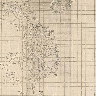
The map is part of a set, which includes “Map of East Asia”, “Map of Southeast Asia”, and “Map of Northeast Asia”. The map covers the area west of the Pearl River, Leizhou Peninsula, Hainan Island, Gulf of Tonkin, Guangxi Province, Yunnan Province to Vietnam, Cambodia, and the border of China and Vietnam. The map adopts the Chinese cartographic grid and a side of each grid inch represents 100 li (approximately 33 miles). Mountains are depicted with pictorial symbols; boundaries in thin lines. The map emphasizes the cities established along coastal and border areas.
The map can be studied with the following map in the National Palace Museum's collection: title: Jiao zhi Zhongnan Baodao qing xing tu (Grand Council file no. 014784).
The map can be studied with the following map in the National Palace Museum's collection: title: Jiao zhi Zhongnan Baodao qing xing tu (Grand Council file no. 014784).