Political and Boundary Maps
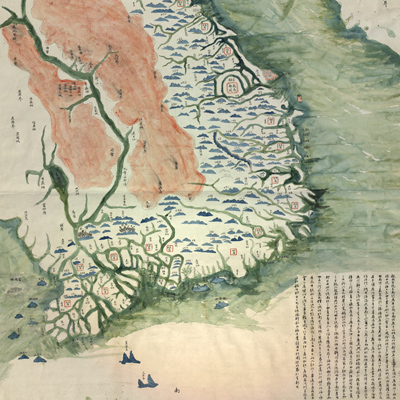
越南全境輿圖
Complete map of Vietnam| Hanyu Pinyin | Yuenan quan jing yu tu |
|---|---|
| Creator | Anonymous |
| Date | Qing Guangxu period, 1885- |
| Measurement | |
| Techniques | Ink and color manuscript |
| Quantity | |
| Categories | |
| Country of Repository | |
| Identifier | Library of Congress |
| Link to Original Database | http://lccn.loc.gov/84696159 |
| Share |
North is at the top. The map depicts mountains, rivers, administrative divisions, cities and towns, Vietnam border areas, and major rivers in Laos and Burma. Mountains are depicted pictorially; rivers in thick lines; the names of the provinces are enclosed in red squares with the capital in the biggest one; the other cities are identified with names without any symbols. The block of text at the bottom right describes Vietnam, which was divided into the south (Nam Ky) and the north (Bac Ky). It lists all the provinces and briefly describes the geography in different parts of the country, including the provincial capital Fuchun (Thuận Hóa). The text also describes land and water transportation, especially in northern Vietnam. The end of the text gives a reference to Liu Yungfu (Luu Vinh Phuc, 1837-1917, style name Yuanting) and his “old army base” which was drawn using a big red circle for easy identification. Liu was a leader of the Black Flags (Co Den), a Chinese paramilitary force that was asked by the Vietnamese government to fight the French invaders in 1885. The map can be studied with the following map in the National Palace Museum's collection: title: Jiao zhi Zhongnan Baodao qing xing tu (Grand Council file no. 014784).