City Maps
昭通府輿圖
Map of Zhaotong Prefecture| Hanyu Pinyin | Zhaotong Fu yu tu |
|---|---|
| Creator | Anonymous |
| Date | Late Qing period, 1908-1911 |
| Measurement | |
| Techniques | Ink and color manuscript |
| Material | paper |
| Quantity | |
| Categories | |
| Country of Repository | |
| Identifier | Library of Congress |
| Link to Original Database | http://lccn.loc.gov/gm71005052 |
| Acquisition Source | Hummel, Arthur William, 1884-1975 |
| Acquisition Method | |
| Acquisition Date | 1930 |
| Share |
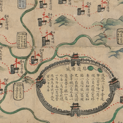
Zhaotong Prefecture is portrayed by a pictorial walled city in a very exaggerated manner to indicate its supreme administrative power in the region; text inside the walled city describes the organization of military personnel. Features are shown by different pictorial symbols. The Green Standard Army is shown in yellow, red, blue, and white; four colors represent central, front, left, and right military units in the Green Standard Army; each unit structure indicates the number of soldiers. Mountains are shown by pictorial mountain symbols; rivers are colored in green; roads in red dotted lines, and checkpoints in red flags.
The map can be studied with the following maps in the National Palace Museum's collection: title: Yunnan jun ying tu (map no. 021502); title: Yunnan Sheng di tu (map no. 021478); title: Yunnan zong tu (map no. 021460-021461); title: Yunnan quan Sheng dao li tu shuo (map no. 021299); title: Yunnan yu di tu shuo (map no. 021302-021303).
The map can be studied with the following maps in the National Palace Museum's collection: title: Yunnan jun ying tu (map no. 021502); title: Yunnan Sheng di tu (map no. 021478); title: Yunnan zong tu (map no. 021460-021461); title: Yunnan quan Sheng dao li tu shuo (map no. 021299); title: Yunnan yu di tu shuo (map no. 021302-021303).