City Maps
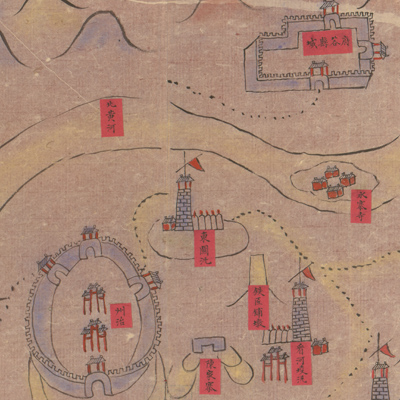
保德州城圖
Map of Baode| Hanyu Pinyin | Baode Zhou cheng tu |
|---|---|
| Creator | Anonymous |
| Date | Mid-Qing period, 1724-1764 |
| Measurement | |
| Techniques | Ink and color manuscript |
| Material | paper |
| Quantity | |
| Categories | |
| Country of Repository | |
| Identifier | Library of Congress |
| Link to Original Database | http://lccn.loc.gov/gm71005156 |
| Share |
Baode Department is now Baode County located in Shanxi province. The map may have been the draft or the basis of a map in a local gazetteer. North is at the top. The map depicts Dezhou, the surrounding area, and military installations. The Yellow River is the most important geographical feature; it appears at the top of the map. All place names are annotated on red labels affixed to the map. Distance mileage to the neighboring counties is noted along the four borders of the map. Landforms are represented by a few sketchy strokes; military camps, watchtowers, barracks, villages, and beacons are indicated with various symbols; roads are portrayed by dotted lines.
The map can be studied with the following map in the National Palace Museum's collection: title: Baode Zhou yan he tu (map no. 021429).
The map can be studied with the following map in the National Palace Museum's collection: title: Baode Zhou yan he tu (map no. 021429).