Military and Traffic Maps
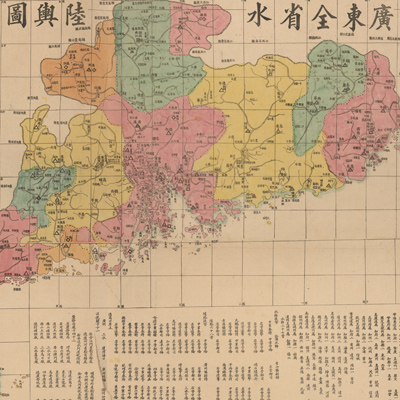
廣東全省水陸輿圖
Map of the Waterways and Roads in Guangdong Province| Hanyu Pinyin | Guangdong quan sheng shui lu yu tu |
|---|---|
| Creator | Li Zhongpei |
| Date | Early Guangxu period, 1887 |
| Measurement | |
| Techniques | Woodcut and hand-colored |
| Material | paper |
| Quantity | |
| Categories | |
| Country of Repository | |
| Identifier | Library of Congress |
| Link to Original Database | http://lccn.loc.gov/gm71005159 |
| Share |
The map uses coordinates with the prime meridian passing through Beijing. The entire map depicts the distribution of river systems and administrative divisions, and includes explanatory text and a legend. The annotation on the bottom right clearly records all levels of administrative civilian and military offices, such as prefecture, municipality, sub-prefecture, county, navy unit, marine unit, and the port cities of Guangzhou, Sanshui, Qiongzhou, Lianzhou Beihai, Chaozhou, and Shantou; eleven tax checkpoints; and forty-two tax collection units. Different colors are used to distinguish different administrative regions. Li Zhongpei mentioned the purpose of making this map. In the 11th Year of Qing Guangxu Reign (1885), the Hemeng Committee surveyed the Sino-Vietnamese border; in the winter of the 13th Year of Qing Guangxu Reign (1887), mapmaker Li Zhongpei was ordered to follow the governor of Guangdong and Guangxi provinces, survey the rivers and seas, and make the map of Guangdong.
This map can be studied with the following map in the National Palace Museum's collection: title: Guangdong Sheng di tu (map no. 021477).
This map can be studied with the following map in the National Palace Museum's collection: title: Guangdong Sheng di tu (map no. 021477).